OceanTACO Dataset & Query API#
A hands-on tour of how OceanTACO structures multi-source ocean data for ML pipelines.
Ocean ML presents a challenge that differs from standard image datasets: data comes from
multiple sensors operating at different resolutions, with different spatial coverage and
sparsity patterns. OceanTACO addresses this with a query-indexed PyTorch Dataset: you
describe where and when you want data as a Query object, and the library handles tile
fetching, spatial cropping, and grid normalization automatically.
This notebook explains the full pipeline step by step:
Query API — what a
Queryis and howPatchSizeworksTraining queries — random ocean-biased sampling with
QueryGeneratorEvaluation queries — deterministic spatial grid for held-out evaluation
From bbox to pixels — how geographic window size determines tensor shape, and how
default_patch_sizenormalizes itDataset instantiation — pre-indexing at init,
__getitem__I/OSample inspection — navigating the output dictionary, visualizing all variables
DataLoader & batching —
collate_ocean_samples, batch shapesQuery persistence — saving and reloading query sets for reproducibility
Prerequisites: familiarity with PyTorch Dataset / DataLoader. No prior oceanography knowledge required.
1. Installation#
# Verify ocean_taco is installed.
# Uncomment one line to install inside this notebook:
%pip install "ocean_taco[hf] @ git+https://github.com/nilsleh/oceanTACO.git@main"
# %pip install ocean-taco[hf]
import ocean_taco
print(f"ocean_taco {ocean_taco.__version__} ready")
Collecting ocean_taco@ git+https://github.com/nilsleh/oceanTACO.git@main (from ocean_taco[hf]@ git+https://github.com/nilsleh/oceanTACO.git@main)
  Cloning https://github.com/nilsleh/oceanTACO.git (to revision main) to /tmp/pip-install-jezhfc8_/ocean-taco_eeaa398fea8a4f5db5df9f10cddccaad
  Running command git clone --filter=blob:none --quiet https://github.com/nilsleh/oceanTACO.git /tmp/pip-install-jezhfc8_/ocean-taco_eeaa398fea8a4f5db5df9f10cddccaad
  Resolved https://github.com/nilsleh/oceanTACO.git to commit 0ef0983b4a9735c2229bd34f90f847c4c303bd34
  Installing build dependencies ... ?25l?25hdone
  Getting requirements to build wheel ... ?25l?25hdone
  Preparing metadata (pyproject.toml) ... ?25l?25hdone
Requirement already satisfied: matplotlib>=3.10 in /usr/local/lib/python3.12/dist-packages (from ocean_taco@ git+https://github.com/nilsleh/oceanTACO.git@main->ocean_taco[hf]@ git+https://github.com/nilsleh/oceanTACO.git@main) (3.10.0)
Requirement already satisfied: numpy<2.1,>=1.26 in /usr/local/lib/python3.12/dist-packages (from ocean_taco@ git+https://github.com/nilsleh/oceanTACO.git@main->ocean_taco[hf]@ git+https://github.com/nilsleh/oceanTACO.git@main) (2.0.2)
Requirement already satisfied: pandas>=2.2 in /usr/local/lib/python3.12/dist-packages (from ocean_taco@ git+https://github.com/nilsleh/oceanTACO.git@main->ocean_taco[hf]@ git+https://github.com/nilsleh/oceanTACO.git@main) (2.2.2)
Requirement already satisfied: requests>=2.31 in /usr/local/lib/python3.12/dist-packages (from ocean_taco@ git+https://github.com/nilsleh/oceanTACO.git@main->ocean_taco[hf]@ git+https://github.com/nilsleh/oceanTACO.git@main) (2.32.4)
Requirement already satisfied: torch>=2.2 in /usr/local/lib/python3.12/dist-packages (from ocean_taco@ git+https://github.com/nilsleh/oceanTACO.git@main->ocean_taco[hf]@ git+https://github.com/nilsleh/oceanTACO.git@main) (2.10.0+cpu)
Requirement already satisfied: tqdm>=4.66 in /usr/local/lib/python3.12/dist-packages (from ocean_taco@ git+https://github.com/nilsleh/oceanTACO.git@main->ocean_taco[hf]@ git+https://github.com/nilsleh/oceanTACO.git@main) (4.67.3)
Requirement already satisfied: xarray>=2025.11.0 in /usr/local/lib/python3.12/dist-packages (from ocean_taco@ git+https://github.com/nilsleh/oceanTACO.git@main->ocean_taco[hf]@ git+https://github.com/nilsleh/oceanTACO.git@main) (2025.12.0)
Collecting cartopy>=0.23.0 (from ocean_taco@ git+https://github.com/nilsleh/oceanTACO.git@main->ocean_taco[hf]@ git+https://github.com/nilsleh/oceanTACO.git@main)
  Downloading cartopy-0.25.0-cp312-cp312-manylinux_2_24_x86_64.manylinux_2_28_x86_64.whl.metadata (6.1 kB)
Collecting tacoreader>=2.4.20 (from ocean_taco@ git+https://github.com/nilsleh/oceanTACO.git@main->ocean_taco[hf]@ git+https://github.com/nilsleh/oceanTACO.git@main)
  Downloading tacoreader-2.4.20-py3-none-any.whl.metadata (3.0 kB)
Requirement already satisfied: shapely>=2.0 in /usr/local/lib/python3.12/dist-packages (from ocean_taco@ git+https://github.com/nilsleh/oceanTACO.git@main->ocean_taco[hf]@ git+https://github.com/nilsleh/oceanTACO.git@main) (2.1.2)
Requirement already satisfied: omegaconf>=2.3 in /usr/local/lib/python3.12/dist-packages (from ocean_taco@ git+https://github.com/nilsleh/oceanTACO.git@main->ocean_taco[hf]@ git+https://github.com/nilsleh/oceanTACO.git@main) (2.3.0)
Collecting pydantic>=2.12.5 (from ocean_taco@ git+https://github.com/nilsleh/oceanTACO.git@main->ocean_taco[hf]@ git+https://github.com/nilsleh/oceanTACO.git@main)
  Downloading pydantic-2.12.5-py3-none-any.whl.metadata (90 kB)
     ━━━━━━━━━━━━━━━━━━━━━━━━━━━━━━━━━━━━━━━━ 90.6/90.6 kB 6.7 MB/s eta 0:00:00
?25hRequirement already satisfied: typer>=0.12 in /usr/local/lib/python3.12/dist-packages (from ocean_taco@ git+https://github.com/nilsleh/oceanTACO.git@main->ocean_taco[hf]@ git+https://github.com/nilsleh/oceanTACO.git@main) (0.24.1)
Requirement already satisfied: rich>=13.0 in /usr/local/lib/python3.12/dist-packages (from ocean_taco@ git+https://github.com/nilsleh/oceanTACO.git@main->ocean_taco[hf]@ git+https://github.com/nilsleh/oceanTACO.git@main) (13.9.4)
Requirement already satisfied: geopandas>=1.0 in /usr/local/lib/python3.12/dist-packages (from ocean_taco@ git+https://github.com/nilsleh/oceanTACO.git@main->ocean_taco[hf]@ git+https://github.com/nilsleh/oceanTACO.git@main) (1.1.3)
Requirement already satisfied: rasterio>=1.3 in /usr/local/lib/python3.12/dist-packages (from ocean_taco@ git+https://github.com/nilsleh/oceanTACO.git@main->ocean_taco[hf]@ git+https://github.com/nilsleh/oceanTACO.git@main) (1.5.0)
Requirement already satisfied: datasets>=2.19 in /usr/local/lib/python3.12/dist-packages (from ocean_taco@ git+https://github.com/nilsleh/oceanTACO.git@main->ocean_taco[hf]@ git+https://github.com/nilsleh/oceanTACO.git@main) (4.0.0)
Requirement already satisfied: huggingface_hub>=0.24 in /usr/local/lib/python3.12/dist-packages (from ocean_taco@ git+https://github.com/nilsleh/oceanTACO.git@main->ocean_taco[hf]@ git+https://github.com/nilsleh/oceanTACO.git@main) (1.7.1)
Requirement already satisfied: packaging>=21 in /usr/local/lib/python3.12/dist-packages (from cartopy>=0.23.0->ocean_taco@ git+https://github.com/nilsleh/oceanTACO.git@main->ocean_taco[hf]@ git+https://github.com/nilsleh/oceanTACO.git@main) (26.0)
Requirement already satisfied: pyshp>=2.3 in /usr/local/lib/python3.12/dist-packages (from cartopy>=0.23.0->ocean_taco@ git+https://github.com/nilsleh/oceanTACO.git@main->ocean_taco[hf]@ git+https://github.com/nilsleh/oceanTACO.git@main) (3.0.3)
Requirement already satisfied: pyproj>=3.3.1 in /usr/local/lib/python3.12/dist-packages (from cartopy>=0.23.0->ocean_taco@ git+https://github.com/nilsleh/oceanTACO.git@main->ocean_taco[hf]@ git+https://github.com/nilsleh/oceanTACO.git@main) (3.7.2)
Requirement already satisfied: filelock in /usr/local/lib/python3.12/dist-packages (from datasets>=2.19->ocean_taco@ git+https://github.com/nilsleh/oceanTACO.git@main->ocean_taco[hf]@ git+https://github.com/nilsleh/oceanTACO.git@main) (3.25.2)
Requirement already satisfied: pyarrow>=15.0.0 in /usr/local/lib/python3.12/dist-packages (from datasets>=2.19->ocean_taco@ git+https://github.com/nilsleh/oceanTACO.git@main->ocean_taco[hf]@ git+https://github.com/nilsleh/oceanTACO.git@main) (18.1.0)
Requirement already satisfied: dill<0.3.9,>=0.3.0 in /usr/local/lib/python3.12/dist-packages (from datasets>=2.19->ocean_taco@ git+https://github.com/nilsleh/oceanTACO.git@main->ocean_taco[hf]@ git+https://github.com/nilsleh/oceanTACO.git@main) (0.3.8)
Requirement already satisfied: xxhash in /usr/local/lib/python3.12/dist-packages (from datasets>=2.19->ocean_taco@ git+https://github.com/nilsleh/oceanTACO.git@main->ocean_taco[hf]@ git+https://github.com/nilsleh/oceanTACO.git@main) (3.6.0)
Requirement already satisfied: multiprocess<0.70.17 in /usr/local/lib/python3.12/dist-packages (from datasets>=2.19->ocean_taco@ git+https://github.com/nilsleh/oceanTACO.git@main->ocean_taco[hf]@ git+https://github.com/nilsleh/oceanTACO.git@main) (0.70.16)
Requirement already satisfied: fsspec<=2025.3.0,>=2023.1.0 in /usr/local/lib/python3.12/dist-packages (from fsspec[http]<=2025.3.0,>=2023.1.0->datasets>=2.19->ocean_taco@ git+https://github.com/nilsleh/oceanTACO.git@main->ocean_taco[hf]@ git+https://github.com/nilsleh/oceanTACO.git@main) (2025.3.0)
Requirement already satisfied: pyyaml>=5.1 in /usr/local/lib/python3.12/dist-packages (from datasets>=2.19->ocean_taco@ git+https://github.com/nilsleh/oceanTACO.git@main->ocean_taco[hf]@ git+https://github.com/nilsleh/oceanTACO.git@main) (6.0.3)
Requirement already satisfied: pyogrio>=0.7.2 in /usr/local/lib/python3.12/dist-packages (from geopandas>=1.0->ocean_taco@ git+https://github.com/nilsleh/oceanTACO.git@main->ocean_taco[hf]@ git+https://github.com/nilsleh/oceanTACO.git@main) (0.12.1)
Requirement already satisfied: hf-xet<2.0.0,>=1.4.2 in /usr/local/lib/python3.12/dist-packages (from huggingface_hub>=0.24->ocean_taco@ git+https://github.com/nilsleh/oceanTACO.git@main->ocean_taco[hf]@ git+https://github.com/nilsleh/oceanTACO.git@main) (1.4.2)
Requirement already satisfied: httpx<1,>=0.23.0 in /usr/local/lib/python3.12/dist-packages (from huggingface_hub>=0.24->ocean_taco@ git+https://github.com/nilsleh/oceanTACO.git@main->ocean_taco[hf]@ git+https://github.com/nilsleh/oceanTACO.git@main) (0.28.1)
Requirement already satisfied: typing-extensions>=4.1.0 in /usr/local/lib/python3.12/dist-packages (from huggingface_hub>=0.24->ocean_taco@ git+https://github.com/nilsleh/oceanTACO.git@main->ocean_taco[hf]@ git+https://github.com/nilsleh/oceanTACO.git@main) (4.15.0)
Requirement already satisfied: contourpy>=1.0.1 in /usr/local/lib/python3.12/dist-packages (from matplotlib>=3.10->ocean_taco@ git+https://github.com/nilsleh/oceanTACO.git@main->ocean_taco[hf]@ git+https://github.com/nilsleh/oceanTACO.git@main) (1.3.3)
Requirement already satisfied: cycler>=0.10 in /usr/local/lib/python3.12/dist-packages (from matplotlib>=3.10->ocean_taco@ git+https://github.com/nilsleh/oceanTACO.git@main->ocean_taco[hf]@ git+https://github.com/nilsleh/oceanTACO.git@main) (0.12.1)
Requirement already satisfied: fonttools>=4.22.0 in /usr/local/lib/python3.12/dist-packages (from matplotlib>=3.10->ocean_taco@ git+https://github.com/nilsleh/oceanTACO.git@main->ocean_taco[hf]@ git+https://github.com/nilsleh/oceanTACO.git@main) (4.62.1)
Requirement already satisfied: kiwisolver>=1.3.1 in /usr/local/lib/python3.12/dist-packages (from matplotlib>=3.10->ocean_taco@ git+https://github.com/nilsleh/oceanTACO.git@main->ocean_taco[hf]@ git+https://github.com/nilsleh/oceanTACO.git@main) (1.5.0)
Requirement already satisfied: pillow>=8 in /usr/local/lib/python3.12/dist-packages (from matplotlib>=3.10->ocean_taco@ git+https://github.com/nilsleh/oceanTACO.git@main->ocean_taco[hf]@ git+https://github.com/nilsleh/oceanTACO.git@main) (11.3.0)
Requirement already satisfied: pyparsing>=2.3.1 in /usr/local/lib/python3.12/dist-packages (from matplotlib>=3.10->ocean_taco@ git+https://github.com/nilsleh/oceanTACO.git@main->ocean_taco[hf]@ git+https://github.com/nilsleh/oceanTACO.git@main) (3.3.2)
Requirement already satisfied: python-dateutil>=2.7 in /usr/local/lib/python3.12/dist-packages (from matplotlib>=3.10->ocean_taco@ git+https://github.com/nilsleh/oceanTACO.git@main->ocean_taco[hf]@ git+https://github.com/nilsleh/oceanTACO.git@main) (2.9.0.post0)
Requirement already satisfied: antlr4-python3-runtime==4.9.* in /usr/local/lib/python3.12/dist-packages (from omegaconf>=2.3->ocean_taco@ git+https://github.com/nilsleh/oceanTACO.git@main->ocean_taco[hf]@ git+https://github.com/nilsleh/oceanTACO.git@main) (4.9.3)
Requirement already satisfied: pytz>=2020.1 in /usr/local/lib/python3.12/dist-packages (from pandas>=2.2->ocean_taco@ git+https://github.com/nilsleh/oceanTACO.git@main->ocean_taco[hf]@ git+https://github.com/nilsleh/oceanTACO.git@main) (2025.2)
Requirement already satisfied: tzdata>=2022.7 in /usr/local/lib/python3.12/dist-packages (from pandas>=2.2->ocean_taco@ git+https://github.com/nilsleh/oceanTACO.git@main->ocean_taco[hf]@ git+https://github.com/nilsleh/oceanTACO.git@main) (2025.3)
Requirement already satisfied: annotated-types>=0.6.0 in /usr/local/lib/python3.12/dist-packages (from pydantic>=2.12.5->ocean_taco@ git+https://github.com/nilsleh/oceanTACO.git@main->ocean_taco[hf]@ git+https://github.com/nilsleh/oceanTACO.git@main) (0.7.0)
Collecting pydantic-core==2.41.5 (from pydantic>=2.12.5->ocean_taco@ git+https://github.com/nilsleh/oceanTACO.git@main->ocean_taco[hf]@ git+https://github.com/nilsleh/oceanTACO.git@main)
  Downloading pydantic_core-2.41.5-cp312-cp312-manylinux_2_17_x86_64.manylinux2014_x86_64.whl.metadata (7.3 kB)
Requirement already satisfied: typing-inspection>=0.4.2 in /usr/local/lib/python3.12/dist-packages (from pydantic>=2.12.5->ocean_taco@ git+https://github.com/nilsleh/oceanTACO.git@main->ocean_taco[hf]@ git+https://github.com/nilsleh/oceanTACO.git@main) (0.4.2)
Requirement already satisfied: affine in /usr/local/lib/python3.12/dist-packages (from rasterio>=1.3->ocean_taco@ git+https://github.com/nilsleh/oceanTACO.git@main->ocean_taco[hf]@ git+https://github.com/nilsleh/oceanTACO.git@main) (2.4.0)
Requirement already satisfied: attrs in /usr/local/lib/python3.12/dist-packages (from rasterio>=1.3->ocean_taco@ git+https://github.com/nilsleh/oceanTACO.git@main->ocean_taco[hf]@ git+https://github.com/nilsleh/oceanTACO.git@main) (25.4.0)
Requirement already satisfied: certifi in /usr/local/lib/python3.12/dist-packages (from rasterio>=1.3->ocean_taco@ git+https://github.com/nilsleh/oceanTACO.git@main->ocean_taco[hf]@ git+https://github.com/nilsleh/oceanTACO.git@main) (2026.2.25)
Requirement already satisfied: click!=8.2.*,>=4.0 in /usr/local/lib/python3.12/dist-packages (from rasterio>=1.3->ocean_taco@ git+https://github.com/nilsleh/oceanTACO.git@main->ocean_taco[hf]@ git+https://github.com/nilsleh/oceanTACO.git@main) (8.3.1)
Requirement already satisfied: cligj>=0.5 in /usr/local/lib/python3.12/dist-packages (from rasterio>=1.3->ocean_taco@ git+https://github.com/nilsleh/oceanTACO.git@main->ocean_taco[hf]@ git+https://github.com/nilsleh/oceanTACO.git@main) (0.7.2)
Requirement already satisfied: charset_normalizer<4,>=2 in /usr/local/lib/python3.12/dist-packages (from requests>=2.31->ocean_taco@ git+https://github.com/nilsleh/oceanTACO.git@main->ocean_taco[hf]@ git+https://github.com/nilsleh/oceanTACO.git@main) (3.4.6)
Requirement already satisfied: idna<4,>=2.5 in /usr/local/lib/python3.12/dist-packages (from requests>=2.31->ocean_taco@ git+https://github.com/nilsleh/oceanTACO.git@main->ocean_taco[hf]@ git+https://github.com/nilsleh/oceanTACO.git@main) (3.11)
Requirement already satisfied: urllib3<3,>=1.21.1 in /usr/local/lib/python3.12/dist-packages (from requests>=2.31->ocean_taco@ git+https://github.com/nilsleh/oceanTACO.git@main->ocean_taco[hf]@ git+https://github.com/nilsleh/oceanTACO.git@main) (2.5.0)
Requirement already satisfied: markdown-it-py>=2.2.0 in /usr/local/lib/python3.12/dist-packages (from rich>=13.0->ocean_taco@ git+https://github.com/nilsleh/oceanTACO.git@main->ocean_taco[hf]@ git+https://github.com/nilsleh/oceanTACO.git@main) (4.0.0)
Requirement already satisfied: pygments<3.0.0,>=2.13.0 in /usr/local/lib/python3.12/dist-packages (from rich>=13.0->ocean_taco@ git+https://github.com/nilsleh/oceanTACO.git@main->ocean_taco[hf]@ git+https://github.com/nilsleh/oceanTACO.git@main) (2.19.2)
Requirement already satisfied: duckdb>=1.3.2 in /usr/local/lib/python3.12/dist-packages (from tacoreader>=2.4.20->ocean_taco@ git+https://github.com/nilsleh/oceanTACO.git@main->ocean_taco[hf]@ git+https://github.com/nilsleh/oceanTACO.git@main) (1.3.2)
Collecting obstore>=0.8.1 (from tacoreader>=2.4.20->ocean_taco@ git+https://github.com/nilsleh/oceanTACO.git@main->ocean_taco[hf]@ git+https://github.com/nilsleh/oceanTACO.git@main)
  Downloading obstore-0.9.2-cp311-abi3-manylinux_2_17_x86_64.manylinux2014_x86_64.whl.metadata (3.9 kB)
Requirement already satisfied: platformdirs<5.0.0,>=4.5.1 in /usr/local/lib/python3.12/dist-packages (from tacoreader>=2.4.20->ocean_taco@ git+https://github.com/nilsleh/oceanTACO.git@main->ocean_taco[hf]@ git+https://github.com/nilsleh/oceanTACO.git@main) (4.9.4)
Collecting pyarrow>=15.0.0 (from datasets>=2.19->ocean_taco@ git+https://github.com/nilsleh/oceanTACO.git@main->ocean_taco[hf]@ git+https://github.com/nilsleh/oceanTACO.git@main)
  Downloading pyarrow-23.0.1-cp312-cp312-manylinux_2_28_x86_64.whl.metadata (3.1 kB)
Collecting tacozip>=0.11.4 (from tacoreader>=2.4.20->ocean_taco@ git+https://github.com/nilsleh/oceanTACO.git@main->ocean_taco[hf]@ git+https://github.com/nilsleh/oceanTACO.git@main)
  Downloading tacozip-0.12.0-cp312-cp312-manylinux_2_17_x86_64.manylinux2014_x86_64.whl.metadata (2.4 kB)
Requirement already satisfied: setuptools in /usr/local/lib/python3.12/dist-packages (from torch>=2.2->ocean_taco@ git+https://github.com/nilsleh/oceanTACO.git@main->ocean_taco[hf]@ git+https://github.com/nilsleh/oceanTACO.git@main) (75.2.0)
Requirement already satisfied: sympy>=1.13.3 in /usr/local/lib/python3.12/dist-packages (from torch>=2.2->ocean_taco@ git+https://github.com/nilsleh/oceanTACO.git@main->ocean_taco[hf]@ git+https://github.com/nilsleh/oceanTACO.git@main) (1.14.0)
Requirement already satisfied: networkx>=2.5.1 in /usr/local/lib/python3.12/dist-packages (from torch>=2.2->ocean_taco@ git+https://github.com/nilsleh/oceanTACO.git@main->ocean_taco[hf]@ git+https://github.com/nilsleh/oceanTACO.git@main) (3.6.1)
Requirement already satisfied: jinja2 in /usr/local/lib/python3.12/dist-packages (from torch>=2.2->ocean_taco@ git+https://github.com/nilsleh/oceanTACO.git@main->ocean_taco[hf]@ git+https://github.com/nilsleh/oceanTACO.git@main) (3.1.6)
Requirement already satisfied: shellingham>=1.3.0 in /usr/local/lib/python3.12/dist-packages (from typer>=0.12->ocean_taco@ git+https://github.com/nilsleh/oceanTACO.git@main->ocean_taco[hf]@ git+https://github.com/nilsleh/oceanTACO.git@main) (1.5.4)
Requirement already satisfied: annotated-doc>=0.0.2 in /usr/local/lib/python3.12/dist-packages (from typer>=0.12->ocean_taco@ git+https://github.com/nilsleh/oceanTACO.git@main->ocean_taco[hf]@ git+https://github.com/nilsleh/oceanTACO.git@main) (0.0.4)
Requirement already satisfied: aiohttp!=4.0.0a0,!=4.0.0a1 in /usr/local/lib/python3.12/dist-packages (from fsspec[http]<=2025.3.0,>=2023.1.0->datasets>=2.19->ocean_taco@ git+https://github.com/nilsleh/oceanTACO.git@main->ocean_taco[hf]@ git+https://github.com/nilsleh/oceanTACO.git@main) (3.13.3)
Requirement already satisfied: anyio in /usr/local/lib/python3.12/dist-packages (from httpx<1,>=0.23.0->huggingface_hub>=0.24->ocean_taco@ git+https://github.com/nilsleh/oceanTACO.git@main->ocean_taco[hf]@ git+https://github.com/nilsleh/oceanTACO.git@main) (4.12.1)
Requirement already satisfied: httpcore==1.* in /usr/local/lib/python3.12/dist-packages (from httpx<1,>=0.23.0->huggingface_hub>=0.24->ocean_taco@ git+https://github.com/nilsleh/oceanTACO.git@main->ocean_taco[hf]@ git+https://github.com/nilsleh/oceanTACO.git@main) (1.0.9)
Requirement already satisfied: h11>=0.16 in /usr/local/lib/python3.12/dist-packages (from httpcore==1.*->httpx<1,>=0.23.0->huggingface_hub>=0.24->ocean_taco@ git+https://github.com/nilsleh/oceanTACO.git@main->ocean_taco[hf]@ git+https://github.com/nilsleh/oceanTACO.git@main) (0.16.0)
Requirement already satisfied: mdurl~=0.1 in /usr/local/lib/python3.12/dist-packages (from markdown-it-py>=2.2.0->rich>=13.0->ocean_taco@ git+https://github.com/nilsleh/oceanTACO.git@main->ocean_taco[hf]@ git+https://github.com/nilsleh/oceanTACO.git@main) (0.1.2)
Requirement already satisfied: six>=1.5 in /usr/local/lib/python3.12/dist-packages (from python-dateutil>=2.7->matplotlib>=3.10->ocean_taco@ git+https://github.com/nilsleh/oceanTACO.git@main->ocean_taco[hf]@ git+https://github.com/nilsleh/oceanTACO.git@main) (1.17.0)
Requirement already satisfied: mpmath<1.4,>=1.1.0 in /usr/local/lib/python3.12/dist-packages (from sympy>=1.13.3->torch>=2.2->ocean_taco@ git+https://github.com/nilsleh/oceanTACO.git@main->ocean_taco[hf]@ git+https://github.com/nilsleh/oceanTACO.git@main) (1.3.0)
Requirement already satisfied: MarkupSafe>=2.0 in /usr/local/lib/python3.12/dist-packages (from jinja2->torch>=2.2->ocean_taco@ git+https://github.com/nilsleh/oceanTACO.git@main->ocean_taco[hf]@ git+https://github.com/nilsleh/oceanTACO.git@main) (3.0.3)
Requirement already satisfied: aiohappyeyeballs>=2.5.0 in /usr/local/lib/python3.12/dist-packages (from aiohttp!=4.0.0a0,!=4.0.0a1->fsspec[http]<=2025.3.0,>=2023.1.0->datasets>=2.19->ocean_taco@ git+https://github.com/nilsleh/oceanTACO.git@main->ocean_taco[hf]@ git+https://github.com/nilsleh/oceanTACO.git@main) (2.6.1)
Requirement already satisfied: aiosignal>=1.4.0 in /usr/local/lib/python3.12/dist-packages (from aiohttp!=4.0.0a0,!=4.0.0a1->fsspec[http]<=2025.3.0,>=2023.1.0->datasets>=2.19->ocean_taco@ git+https://github.com/nilsleh/oceanTACO.git@main->ocean_taco[hf]@ git+https://github.com/nilsleh/oceanTACO.git@main) (1.4.0)
Requirement already satisfied: frozenlist>=1.1.1 in /usr/local/lib/python3.12/dist-packages (from aiohttp!=4.0.0a0,!=4.0.0a1->fsspec[http]<=2025.3.0,>=2023.1.0->datasets>=2.19->ocean_taco@ git+https://github.com/nilsleh/oceanTACO.git@main->ocean_taco[hf]@ git+https://github.com/nilsleh/oceanTACO.git@main) (1.8.0)
Requirement already satisfied: multidict<7.0,>=4.5 in /usr/local/lib/python3.12/dist-packages (from aiohttp!=4.0.0a0,!=4.0.0a1->fsspec[http]<=2025.3.0,>=2023.1.0->datasets>=2.19->ocean_taco@ git+https://github.com/nilsleh/oceanTACO.git@main->ocean_taco[hf]@ git+https://github.com/nilsleh/oceanTACO.git@main) (6.7.1)
Requirement already satisfied: propcache>=0.2.0 in /usr/local/lib/python3.12/dist-packages (from aiohttp!=4.0.0a0,!=4.0.0a1->fsspec[http]<=2025.3.0,>=2023.1.0->datasets>=2.19->ocean_taco@ git+https://github.com/nilsleh/oceanTACO.git@main->ocean_taco[hf]@ git+https://github.com/nilsleh/oceanTACO.git@main) (0.4.1)
Requirement already satisfied: yarl<2.0,>=1.17.0 in /usr/local/lib/python3.12/dist-packages (from aiohttp!=4.0.0a0,!=4.0.0a1->fsspec[http]<=2025.3.0,>=2023.1.0->datasets>=2.19->ocean_taco@ git+https://github.com/nilsleh/oceanTACO.git@main->ocean_taco[hf]@ git+https://github.com/nilsleh/oceanTACO.git@main) (1.23.0)
Downloading cartopy-0.25.0-cp312-cp312-manylinux_2_24_x86_64.manylinux_2_28_x86_64.whl (11.8 MB)
   ━━━━━━━━━━━━━━━━━━━━━━━━━━━━━━━━━━━━━━━━ 11.8/11.8 MB 60.8 MB/s eta 0:00:00
?25hDownloading pydantic-2.12.5-py3-none-any.whl (463 kB)
   ━━━━━━━━━━━━━━━━━━━━━━━━━━━━━━━━━━━━━━━━ 463.6/463.6 kB 31.0 MB/s eta 0:00:00
?25hDownloading pydantic_core-2.41.5-cp312-cp312-manylinux_2_17_x86_64.manylinux2014_x86_64.whl (2.1 MB)
   ━━━━━━━━━━━━━━━━━━━━━━━━━━━━━━━━━━━━━━━━ 2.1/2.1 MB 78.7 MB/s eta 0:00:00
?25hDownloading tacoreader-2.4.20-py3-none-any.whl (98 kB)
   ━━━━━━━━━━━━━━━━━━━━━━━━━━━━━━━━━━━━━━━━ 98.9/98.9 kB 8.3 MB/s eta 0:00:00
?25hDownloading obstore-0.9.2-cp311-abi3-manylinux_2_17_x86_64.manylinux2014_x86_64.whl (4.2 MB)
   ━━━━━━━━━━━━━━━━━━━━━━━━━━━━━━━━━━━━━━━━ 4.2/4.2 MB 80.4 MB/s eta 0:00:00
?25hDownloading pyarrow-23.0.1-cp312-cp312-manylinux_2_28_x86_64.whl (47.6 MB)
   ━━━━━━━━━━━━━━━━━━━━━━━━━━━━━━━━━━━━━━━━ 47.6/47.6 MB 12.0 MB/s eta 0:00:00
?25hDownloading tacozip-0.12.0-cp312-cp312-manylinux_2_17_x86_64.manylinux2014_x86_64.whl (78 kB)
   ━━━━━━━━━━━━━━━━━━━━━━━━━━━━━━━━━━━━━━━━ 78.6/78.6 kB 6.9 MB/s eta 0:00:00
?25hBuilding wheels for collected packages: ocean_taco
  Building wheel for ocean_taco (pyproject.toml) ... ?25l?25hdone
  Created wheel for ocean_taco: filename=ocean_taco-0.1.0-py3-none-any.whl size=244295 sha256=e5cc94290cb325ed28576bf72e072c7a247be51e02de1f6ae5cb9cd6398f2064
  Stored in directory: /tmp/pip-ephem-wheel-cache-f0xp93qg/wheels/d8/34/2b/2c84305c60134843b3e06b465d3f03c97f3873f80607119cc0
Successfully built ocean_taco
Installing collected packages: tacozip, pydantic-core, pyarrow, obstore, pydantic, tacoreader, cartopy, ocean_taco
  Attempting uninstall: pydantic-core
    Found existing installation: pydantic_core 2.41.4
    Uninstalling pydantic_core-2.41.4:
      Successfully uninstalled pydantic_core-2.41.4
  Attempting uninstall: pyarrow
    Found existing installation: pyarrow 18.1.0
    Uninstalling pyarrow-18.1.0:
      Successfully uninstalled pyarrow-18.1.0
  Attempting uninstall: pydantic
    Found existing installation: pydantic 2.12.3
    Uninstalling pydantic-2.12.3:
      Successfully uninstalled pydantic-2.12.3
ERROR: pip's dependency resolver does not currently take into account all the packages that are installed. This behaviour is the source of the following dependency conflicts.
gradio 5.50.0 requires pydantic<=2.12.3,>=2.0, but you have pydantic 2.12.5 which is incompatible.
Successfully installed cartopy-0.25.0 obstore-0.9.2 ocean_taco-0.1.0 pyarrow-23.0.1 pydantic-2.12.5 pydantic-core-2.41.5 tacoreader-2.4.20 tacozip-0.12.0
ocean_taco 0.1.0 ready
2. Imports#
import os
import warnings
from pathlib import Path

import cartopy
import cartopy.crs as ccrs
import cartopy.feature as cfeature
import matplotlib.patches as mpatches
import matplotlib.pyplot as plt
import numpy as np
import seaborn as sns
import torch
from torch.utils.data import DataLoader

from ocean_taco.dataset import (
    OceanTACODataset,
    PatchSize,
    Query,
    QueryGenerator,
    collate_ocean_samples,
)
from ocean_taco.dataset.retrieve import HF_DEFAULT_URL

warnings.filterwarnings("ignore", category=RuntimeWarning)


def _configure_cartopy_dir(path: str):
    p = Path(path).expanduser()
    p.mkdir(parents=True, exist_ok=True)
    os.environ["CARTOPY_USER_DIR"] = str(p)
    cartopy.config["data_dir"] = str(p)


_configure_cartopy_dir("./.cartopy")
3. Configuration#
# -- Configuration --
HF_URL    = HF_DEFAULT_URL
CACHE_DIR = None   # set to a local path string to cache downloaded tiles
OUTPUT    = None   # set to a file path prefix to save figures, e.g. "./figures/ml_dataset"

# Study region: North Atlantic / Gulf Stream area.
# (lon_min, lon_max, lat_min, lat_max)
STUDY_BBOX = (-80, -10, 10, 55)

# Date ranges
TRAIN_DATE_RANGE = ("2023-04-01", "2023-06-30")  # 3-month training window
EVAL_DATE_RANGE  = ("2023-07-01", "2023-08-30")  # 1-month eval window (demo speed)

# Patch and model-facing image size
PATCH_SIZE = PatchSize(10, "deg")  # 10 deg x 10 deg geographic window per sample
IMAGE_SIZE = 64  # fixed model interface for most channels

# Variable-specific output patch sizes (H, W) in pixels.
# These are passed via OceanTACODataset(..., patch_sizes=PATCH_SIZES) and override IMAGE_SIZE.
# We intentionally keep higher detail for L3 SSH products.
PATCH_SIZES = {
    "l3_ssh": (96, 96),
    "l3_swot": (128, 128),
}

# Native resolutions (deg/pixel) for resolution diagnostics in this tutorial.
NATIVE_RES_DEG = {
    "l4_sst": 0.25,
    "l4_sss": 0.25,
    "l3_ssh": 0.25,
    "l4_ssh": 0.25,
    "l3_swot": 0.008,  # approximate along-track spacing for didactic comparison
}

# Convert patch size to degrees; for km patches, use center latitude of study area.
if PATCH_SIZE.unit == "deg":
    patch_lon_deg, patch_lat_deg = PATCH_SIZE.value, PATCH_SIZE.value
else:
    center_lat = 0.5 * (STUDY_BBOX[2] + STUDY_BBOX[3])
    patch_lon_deg, patch_lat_deg = PATCH_SIZE.to_degrees(center_lat=center_lat)

print(
    f"Model-default output size: {IMAGE_SIZE}x{IMAGE_SIZE} px; "
    f"patch footprint ~({patch_lon_deg:.2f}deg x {patch_lat_deg:.2f}deg)"
)
print(f"Per-variable overrides: {PATCH_SIZES}")

# Variables
INPUT_VARS  = ["l4_sst", "l4_sss", "l3_swot", "l3_ssh"]
TARGET_VARS = ["l4_ssh"]
Model-default output size: 64x64 px; patch footprint ~(10.00deg x 10.00deg)
Per-variable overrides: {'l3_ssh': (96, 96), 'l3_swot': (128, 128)}
4. Section 1 — What is a Query?#
A Query is a plain Python dataclass with six fields that describe a single training or
evaluation sample:
Field |
Type |
Meaning |
|---|---|---|
|
float |
Longitude extent of the patch |
|
float |
Latitude extent of the patch |
|
str |
Date/time window to load data from |
The .bbox property returns (lon_min, lon_max, lat_min, lat_max) as a tuple —
the convention used throughout the OceanTACO API.
Key design principle: a Query is a pure data specification. It contains no file
handles, no open connections, and no loaded arrays. This makes queries serializable,
reproducible, and safe to pass across DataLoader worker processes.
PatchSize and latitude distortion#
A PatchSize object lets you specify patch size in degrees or kilometers. When using
kilometers, it automatically corrects for latitude distortion: longitude degrees shrink
toward the poles (cos(latitude) factor), while latitude degrees are roughly constant
at ~111 km/degree.
# Construct a query manually to see its fields
manual_query = Query(
    lon_min=-70, lon_max=-60,
    lat_min=35,  lat_max=45,
    time_start="2023-04-15",
    time_end="2023-04-15",
)
print(f"bbox property : {manual_query.bbox}")
print(f"dict form     : {manual_query.to_dict()}")

# PatchSize: km → degrees, with latitude correction
print("\nPatchSize latitude distortion demo:")
for lat in [0, 30, 45, 60]:
    ps = PatchSize(500, "km")
    lon_deg, lat_deg = ps.to_degrees(center_lat=lat)
    print(f"  500 km at lat={lat:2d}° → lon_deg={lon_deg:.2f}°,  lat_deg={lat_deg:.2f}°")

print(f"\nOur PATCH_SIZE ({PATCH_SIZE}) in degrees: {PATCH_SIZE.to_degrees()}")
bbox property : (-70, -60, 35, 45)
dict form     : {'lon_min': -70, 'lon_max': -60, 'lat_min': 35, 'lat_max': 45, 'time_start': '2023-04-15', 'time_end': '2023-04-15'}

PatchSize latitude distortion demo:
  500 km at lat= 0° → lon_deg=4.50°,  lat_deg=4.50°
  500 km at lat=30° → lon_deg=5.20°,  lat_deg=4.50°
  500 km at lat=45° → lon_deg=6.37°,  lat_deg=4.50°
  500 km at lat=60° → lon_deg=9.01°,  lat_deg=4.50°

Our PATCH_SIZE (10deg) in degrees: (10, 10)
5. Section 2 — Generating Training Queries#
QueryGenerator.generate_training_queries samples random spatial patches and temporal
windows, with three key design choices:
Ocean bias via land mask. When a land_mask_path is provided, the generator uses a
pre-computed 0.25° global land mask (based on Natural Earth geometries) to reject patches
with more than max_land_fraction land coverage. This ensures training samples are
predominantly over open ocean. Without a mask path (as used here for demo speed), all
candidate patches within bbox_constraint are accepted.
Temporal sampling. Each query’s start date is drawn uniformly at random from
date_range. The query time window spans time_window_days days from the start date,
allowing you to load e.g. a single-day snapshot (time_window_days=1) or a multi-day
composite.
Overlap control. The max_spatial_overlap parameter (IoU threshold, default 1.0 =
disabled) can be used to prevent near-duplicate spatial patches from dominating the
training distribution. Setting it to e.g. 0.3 rejects any candidate patch that overlaps
more than 30% with an already-accepted patch.
qg = QueryGenerator()  # no land_mask_path → skips land filtering (fast demo)

train_queries = qg.generate_training_queries(
    n_queries=100,
    patch_size=PATCH_SIZE,
    date_range=TRAIN_DATE_RANGE,
    bbox_constraint=STUDY_BBOX,
    time_window_days=1,
    max_land_fraction=0.3,
    seed=42,
)

q = train_queries[0]
print(f"Generated {len(train_queries)} training queries")
print(f"\nFirst query:")
print(f"  bbox:        {q.bbox}")
print(f"  time_start:  {q.time_start}")
print(f"  time_end:    {q.time_end}")
print(f"  patch size:  lon={q.lon_max - q.lon_min:.1f}°  lat={q.lat_max - q.lat_min:.1f}°")
Generating 100 training queries...
Generated 100 queries from 100 candidates
Generated 100 training queries

First query:
  bbox:        (-30.581661323117572, -20.581661323117572, 39.82802218501835, 49.82802218501835)
  time_start:  2023-04-02
  time_end:    2023-04-02
  patch size:  lon=10.0°  lat=10.0°
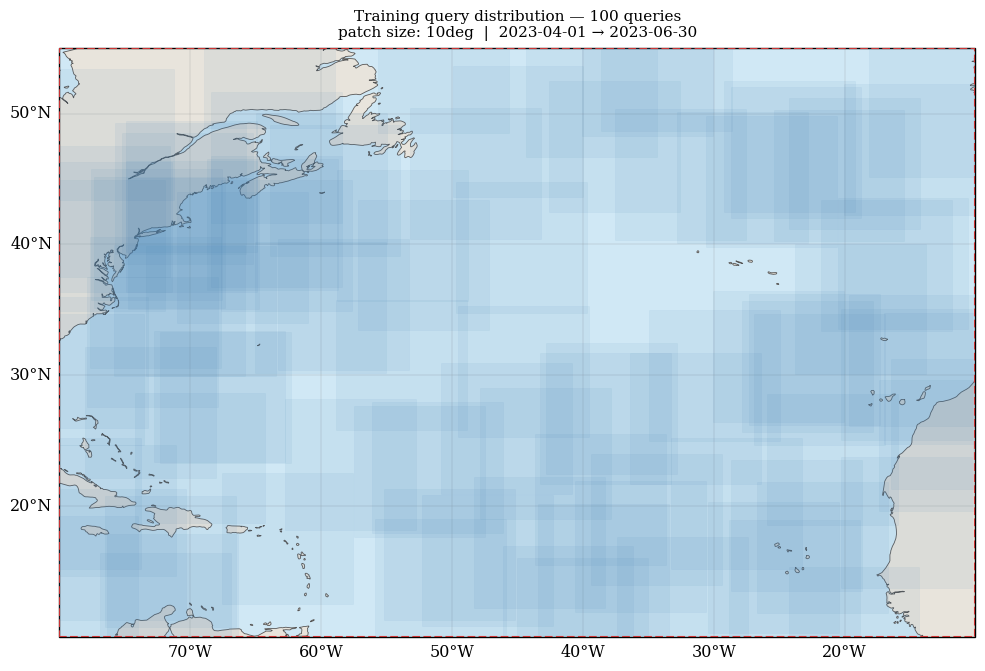
# Figure 1: Spatial distribution of training queries
sns.set_context("paper", font_scale=1.2)
plt.rcParams["font.family"] = "serif"

fig, ax = plt.subplots(
    1, 1, figsize=(10, 7),
    subplot_kw={"projection": ccrs.PlateCarree()},
)

lon_min, lon_max, lat_min, lat_max = STUDY_BBOX
ax.set_extent([lon_min, lon_max, lat_min, lat_max], crs=ccrs.PlateCarree())
ax.add_feature(cfeature.OCEAN, facecolor="#d0e8f5", zorder=0)
ax.add_feature(cfeature.LAND, facecolor="#e8e4dc", edgecolor="none", zorder=1)
ax.coastlines(linewidth=0.6, color="#555", zorder=2)
gl = ax.gridlines(draw_labels=True, linewidth=0.3, alpha=0.5, color="gray", zorder=0)
gl.top_labels = False
gl.right_labels = False

# Draw each query bbox as a semi-transparent rectangle.
# Where many queries overlap, the rectangles stack to a darker blue —
# giving a natural 2D density map with no extra computation.
for q in train_queries:
    w = q.lon_max - q.lon_min
    h = q.lat_max - q.lat_min
    rect = mpatches.Rectangle(
        (q.lon_min, q.lat_min), w, h,
        linewidth=0.4, edgecolor="steelblue",
        facecolor="steelblue", alpha=0.08,
        transform=ccrs.PlateCarree(), zorder=3,
    )
    ax.add_patch(rect)

# Outline the study region
study_rect = mpatches.Rectangle(
    (lon_min, lat_min), lon_max - lon_min, lat_max - lat_min,
    linewidth=1.5, edgecolor="#cc3333", facecolor="none",
    transform=ccrs.PlateCarree(), zorder=4, linestyle="--",
)
ax.add_patch(study_rect)

ax.set_title(
    f"Training query distribution — {len(train_queries)} queries\n"
    f"patch size: {PATCH_SIZE}  |  "
    f"{TRAIN_DATE_RANGE[0]} → {TRAIN_DATE_RANGE[1]}",
    fontsize=11, pad=8,
)
plt.tight_layout()

if OUTPUT:
    plt.savefig(f"{OUTPUT}_train_queries.png", dpi=300, bbox_inches="tight")
plt.show()
/usr/local/lib/python3.12/dist-packages/cartopy/io/__init__.py:242: DownloadWarning: Downloading: https://naturalearth.s3.amazonaws.com/50m_physical/ne_50m_ocean.zip
  warnings.warn(f'Downloading: {url}', DownloadWarning)
/usr/local/lib/python3.12/dist-packages/cartopy/io/__init__.py:242: DownloadWarning: Downloading: https://naturalearth.s3.amazonaws.com/50m_physical/ne_50m_land.zip
  warnings.warn(f'Downloading: {url}', DownloadWarning)
/usr/local/lib/python3.12/dist-packages/cartopy/io/__init__.py:242: DownloadWarning: Downloading: https://naturalearth.s3.amazonaws.com/50m_physical/ne_50m_coastline.zip
  warnings.warn(f'Downloading: {url}', DownloadWarning)
6. Section 3 — Evaluation Queries: Systematic Grid#
generate_eval_queries builds a deterministic grid rather than random samples.
It tiles the entire bbox with non-overlapping (or partially overlapping) patches,
then sweeps across dates at a fixed temporal_stride_days interval.
spatial_overlap=0.0→ non-overlapping tiles (good for independent evaluation)spatial_overlap=0.5→ tiles share half their width/height with neighbors (good for sliding-window inference where you need predictions at every point)Eval queries are always returned sorted chronologically, which makes it easy to stream them in time order during evaluation.
The key distinction from training queries:
Training |
Evaluation |
|
|---|---|---|
Spatial placement |
Random |
Deterministic grid |
Temporal placement |
Random within date_range |
Fixed stride |
Reproducibility |
Via |
Fully deterministic |
Typical use |
Training loop |
Metrics, held-out evaluation |
eval_queries = qg.generate_eval_queries(
    bbox=STUDY_BBOX,
    patch_size=PATCH_SIZE,
    date_range=EVAL_DATE_RANGE,
    spatial_overlap=0.0,
    temporal_stride_days=7,   # one query set per week
    time_window_days=1,
)

print(f"Training queries : {len(train_queries):4d}  (random,    {TRAIN_DATE_RANGE[0]} → {TRAIN_DATE_RANGE[1]})")
print(f"Eval queries     : {len(eval_queries):4d}  (grid,      {EVAL_DATE_RANGE[0]} → {EVAL_DATE_RANGE[1]}, 7-day stride)")
print(f"\nFirst eval query: {eval_queries[0].to_dict()}")
print(f"Last  eval query: {eval_queries[-1].to_dict()}")
Generating eval grid: 7x5x9 = 315 candidates
Generated 315 valid eval queries
Training queries :  100  (random,    2023-04-01 → 2023-06-30)
Eval queries     :  315  (grid,      2023-07-01 → 2023-08-30, 7-day stride)

First eval query: {'lon_min': -80.0, 'lon_max': -70.0, 'lat_min': 10.0, 'lat_max': 20.0, 'time_start': '2023-07-01', 'time_end': '2023-07-01'}
Last  eval query: {'lon_min': -20.0, 'lon_max': -10.0, 'lat_min': 45.0, 'lat_max': 55.0, 'time_start': '2023-08-26', 'time_end': '2023-08-26'}
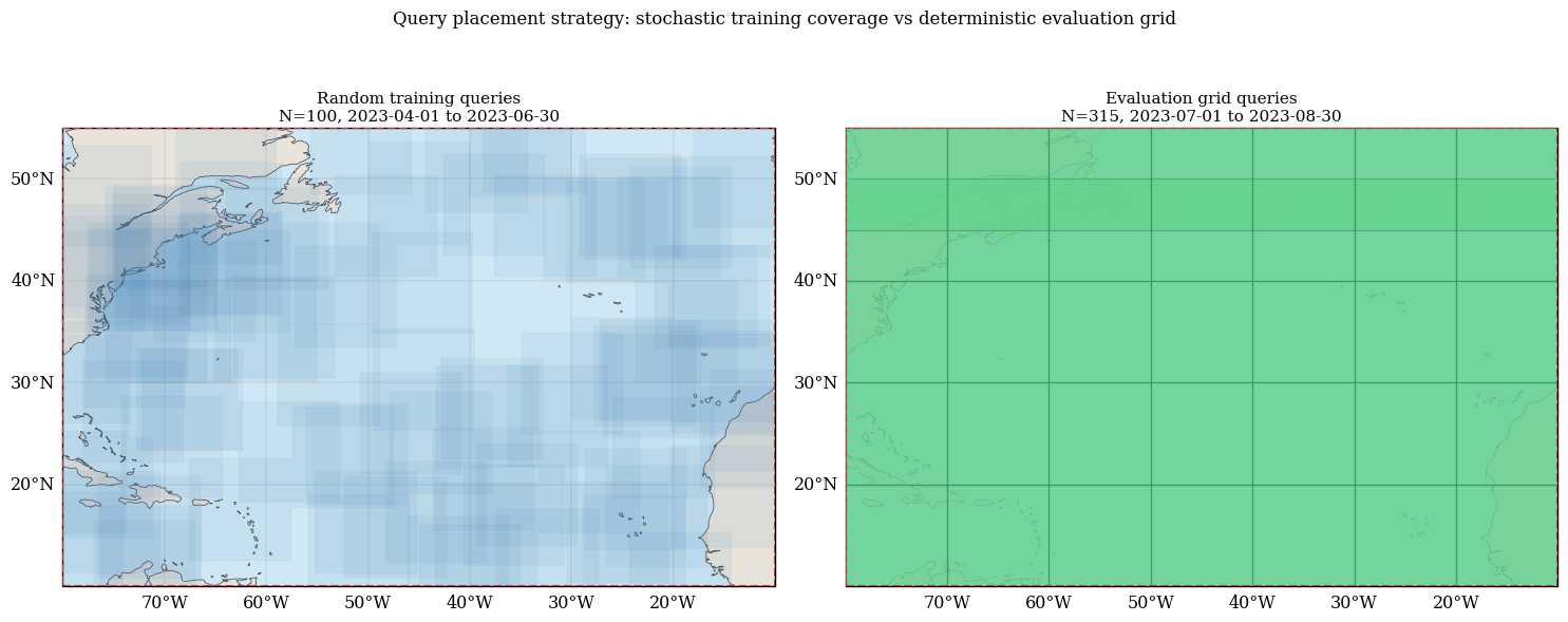
Visual intuition: random vs grid queries#
The two query modes have distinct spatial patterns:
Training queries are randomly placed, so patches overlap irregularly and coverage density is uneven.
Evaluation queries are systematic, forming a regular lattice that covers the study region uniformly.
In the figure below:
Left panel shows training queries (random overlap pattern).
Right panel shows evaluation queries (structured grid pattern).
# Figure 2: Compare random training queries vs systematic eval queries
sns.set_context("paper", font_scale=1.2)
plt.rcParams["font.family"] = "serif"

fig, axes = plt.subplots(
    1, 2, figsize=(15, 6),
    subplot_kw={"projection": ccrs.PlateCarree()},
)

lon_min, lon_max, lat_min, lat_max = STUDY_BBOX

for ax in axes:
    ax.set_extent([lon_min, lon_max, lat_min, lat_max], crs=ccrs.PlateCarree())
    ax.add_feature(cfeature.OCEAN, facecolor="#d0e8f5", zorder=0)
    ax.add_feature(cfeature.LAND, facecolor="#e8e4dc", edgecolor="none", zorder=1)
    ax.coastlines(linewidth=0.6, color="#555", zorder=2)
    gl = ax.gridlines(draw_labels=True, linewidth=0.3, alpha=0.5, color="gray", zorder=0)
    gl.top_labels = False
    gl.right_labels = False

# Left: random training queries
for q in train_queries:
    rect = mpatches.Rectangle(
        (q.lon_min, q.lat_min),
        q.lon_max - q.lon_min,
        q.lat_max - q.lat_min,
        linewidth=0.35,
        edgecolor="steelblue",
        facecolor="steelblue",
        alpha=0.08,
        transform=ccrs.PlateCarree(),
        zorder=3,
    )
    axes[0].add_patch(rect)

# Right: deterministic eval grid queries
for q in eval_queries:
    rect = mpatches.Rectangle(
        (q.lon_min, q.lat_min),
        q.lon_max - q.lon_min,
        q.lat_max - q.lat_min,
        linewidth=0.8,
        edgecolor="#2f855a",
        facecolor="#68d391",
        alpha=0.20,
        transform=ccrs.PlateCarree(),
        zorder=3,
    )
    axes[1].add_patch(rect)

# Outline study bbox in both panels
for ax in axes:
    study_rect = mpatches.Rectangle(
        (lon_min, lat_min), lon_max - lon_min, lat_max - lat_min,
        linewidth=1.5, edgecolor="#cc3333", facecolor="none",
        transform=ccrs.PlateCarree(), zorder=4, linestyle="--",
    )
    ax.add_patch(study_rect)

axes[0].set_title(
    f"Random training queries\nN={len(train_queries)}, {TRAIN_DATE_RANGE[0]} to {TRAIN_DATE_RANGE[1]}",
    fontsize=11,
)
axes[1].set_title(
    f"Evaluation grid queries\nN={len(eval_queries)}, {EVAL_DATE_RANGE[0]} to {EVAL_DATE_RANGE[1]}",
    fontsize=11,
)

fig.suptitle(
    "Query placement strategy: stochastic training coverage vs deterministic evaluation grid",
    fontsize=12,
    y=1.02,
)
plt.tight_layout()

if OUTPUT:
    plt.savefig(f"{OUTPUT}_train_vs_eval_queries.png", dpi=300, bbox_inches="tight")
plt.show()
7. Section 4 – From Bbox to Pixels: The Full Resolution Chain#
From an ML perspective, there are two competing goals:
Keep a stable model interface (fixed channel sizes for batching and architecture simplicity).
Preserve as much native spatial information as possible.
In this notebook we use a model-first default and then selective per-variable overrides:
Default:
IMAGE_SIZE = 64for most channels.Overrides via
patch_sizes:l3_ssh -> 96x96,l3_swot -> 128x128.
This is exactly what OceanTACODataset(..., default_patch_size=..., patch_sizes=...) is for.
Step 1: Query bbox defines the geographic window#
A PatchSize(10, "deg") means each query covers a 10 deg x 10 deg patch.
This is the geographic footprint of every sample.
Step 2: Native source resolution determines raw pixel count#
Each data source has a fixed native resolution baked into its NetCDF files:
Variable |
Source |
Native res |
Approx raw pixels for 10 deg patch |
|---|---|---|---|
|
L4 gridded |
0.25 deg/px |
40 x 40 |
|
L4 gridded |
0.25 deg/px |
40 x 40 |
|
L3 nadir altimetry |
0.25 deg/px (re-gridded) |
40 x 40 |
|
L4 DUACS |
0.25 deg/px |
40 x 40 |
|
SWOT wide-swath |
~0.008 deg/px along-track |
much denser, sparse swath |
SWOT (l3_swot) is fundamentally different: it is a sparse along-track swath, not a
regular grid. Only pixels that happen to fall within the bbox on that date are present;
most pixels are NaN (or zero after NaN-filling). This is why SWOT and SSH variables
use a dark background in visualizations.
Step 3: Dataset resizing policy (default + overrides)#
OceanTACODataset applies this logic for gridded variables:
Use
patch_sizes[var]when provided.Otherwise use
default_patch_size.Point sources (e.g., Argo) are not resized.
So in our setup:
l4_sst,l4_sss,l4_ssh->64x64(default)l3_ssh->96x96(override)l3_swot->128x128(override)
Step 4: What resize does internally#
For gridded variables, the dataset calls _interpolate_to_patch(data, (H, W)).
This uses bilinear interpolation with NaN-mask normalization, so no-data regions are not
allowed to bleed strongly into valid regions.
Step 5: Implication for model design#
With variable-specific patch sizes, channels no longer have identical spatial shapes. That is often desirable for fidelity, but requires downstream handling:
per-variable encoders,
explicit resampling to a common resolution before fusion, or
custom multi-resolution fusion blocks.
If you prefer strict same-shape channels everywhere, omit patch_sizes and rely only on
default_patch_size.
# Resolution summary: native estimate vs requested output size per variable
print(
    f"PATCH_SIZE = {PATCH_SIZE} -> geographic window "
    f"({patch_lon_deg:.2f}deg x {patch_lat_deg:.2f}deg)"
)
print(f"Default output size : {IMAGE_SIZE}x{IMAGE_SIZE}")
print(f"Overrides (patch_sizes): {PATCH_SIZES}")
print()

header = f"{'Variable':<12} {'Native res':>12} {'Native px':>12} {'Requested px':>14} {'Resize ratio':>12}"
print(header)
print("-" * len(header))

for var in INPUT_VARS + TARGET_VARS:
    req_h, req_w = PATCH_SIZES.get(var, (IMAGE_SIZE, IMAGE_SIZE))
    native_res = NATIVE_RES_DEG.get(var)

    if native_res is not None:
        native_h = int(round(patch_lat_deg / native_res))
        native_w = int(round(patch_lon_deg / native_res))
        ratio_h = req_h / max(native_h, 1)
        ratio_w = req_w / max(native_w, 1)
        native_res_str = f"{native_res:.3f}"
        native_px_str = f"{native_h}x{native_w}"
        ratio_str = f"{ratio_h:.2f}x/{ratio_w:.2f}x"
    else:
        native_res_str = "unknown"
        native_px_str = "irregular"
        ratio_str = "n/a"

    print(
        f"{var:<12} {native_res_str:>12} {native_px_str:>12} "
        f"{f'{req_h}x{req_w}':>14} {ratio_str:>12}"
    )

print()
print("Interpretation:")
print("- ratio close to 1.0x means requested size is near native sampling")
print("- >1.0x means upsampling, <1.0x means downsampling")
print("- l3_swot is sparse/irregular, so this ratio is only a rough guide")
PATCH_SIZE = 10deg -> geographic window (10.00deg x 10.00deg)
Default output size : 64x64
Overrides (patch_sizes): {'l3_ssh': (96, 96), 'l3_swot': (128, 128)}

Variable       Native res    Native px   Requested px Resize ratio
------------------------------------------------------------------
l4_sst              0.250        40x40          64x64  1.60x/1.60x
l4_sss              0.250        40x40          64x64  1.60x/1.60x
l3_swot             0.008    1250x1250        128x128  0.10x/0.10x
l3_ssh              0.250        40x40          96x96  2.40x/2.40x
l4_ssh              0.250        40x40          64x64  1.60x/1.60x

Interpretation:
- ratio close to 1.0x means requested size is near native sampling
- >1.0x means upsampling, <1.0x means downsampling
- l3_swot is sparse/irregular, so this ratio is only a rough guide
8. Section 5 — Dataset Instantiation#
OceanTACODataset.__init__ runs a single SQL query to the TACO catalog that fetches
the file-level index covering all queries across the entire time range, then splits the
results by per-query date range in memory. This one-shot pre-indexing is what makes the
dataset safe for DataLoader with num_workers > 0: worker processes never touch
tacoreader or the catalog; they only use the pre-built file index.
The init step makes one network request to the HuggingFace catalog (~5–30 s depending
on network speed). All subsequent __getitem__ calls do byte-range HTTP reads directly
to individual tile files.
Demo note: We pass
train_queries[:20]here so the init completes quickly. In real training, pass the full query list.
print("Initializing dataset (one network request to HF catalog) ...")
dataset = OceanTACODataset(
    taco_path=HF_URL,
    queries=train_queries[:20],   # slice for demo speed
    input_variables=INPUT_VARS,
    target_variables=TARGET_VARS,
    default_patch_size=(IMAGE_SIZE, IMAGE_SIZE),
    patch_sizes=PATCH_SIZES,
    temporal_agg="mean",
)

print(f"Dataset ready: {len(dataset)} samples")
print(f"Input variables:  {dataset.input_variables}")
print(f"Target variables: {dataset.target_variables}")
print("\nRequested output patch sizes (H, W):")
for var in INPUT_VARS + TARGET_VARS:
    req = PATCH_SIZES.get(var, (IMAGE_SIZE, IMAGE_SIZE))
    tag = "override" if var in PATCH_SIZES else "default"
    print(f"  {var:<12}: {req}  [{tag}]")
Initializing dataset (one network request to HF catalog) ...
Dataset ready: 20 samples
Input variables:  ['l4_sst', 'l4_sss', 'l3_swot', 'l3_ssh']
Target variables: ['l4_ssh']

Requested output patch sizes (H, W):
  l4_sst      : (64, 64)  [default]
  l4_sss      : (64, 64)  [default]
  l3_swot     : (128, 128)  [override]
  l3_ssh      : (96, 96)  [override]
  l4_ssh      : (64, 64)  [default]
9. Section 6 — Inspecting a Single Sample#
dataset[i] returns a nested dictionary with four top-level keys:
sample = {
    "inputs": {
        "l4_sst":  {"data": Tensor(H, W), "lats": Tensor(H), "lons": Tensor(W)},
        "l4_sss":  {"data": Tensor(H, W), "lats": Tensor(H), "lons": Tensor(W)},
        "l3_swot": {"data": Tensor(H, W), "lats": Tensor(H), "lons": Tensor(W)},
        "l3_ssh":  {"data": Tensor(H, W), "lats": Tensor(H), "lons": Tensor(W)},
    },
    "targets": {
        "l4_ssh":  {"data": Tensor(H, W), "lats": Tensor(H), "lons": Tensor(W)},
    },
    "coords": {"lat": Tensor(H), "lon": Tensor(W)},  # from first available variable
    "metadata": {
        "bbox":       (lon_min, lon_max, lat_min, lat_max),
        "time_range": (time_start, time_end),
        "n_files":    int,  # number of tile files loaded for this query
    },
}
Important edge cases:
If no data files exist for a variable at the query’s bbox/date, the value is
Noneinstead of a dict.lats/lonsare 1D coordinate arrays for the regular grid (after resize:np.linspace). For point sources like Argo floats, they would be the individual float positions.NaN values in the original data are replaced with
0.0after loading (use the data mask froml3_swotvisualizations to distinguish zero-signal from no-data).
sample = dataset[0]

print("=== Sample metadata ===")
meta = sample["metadata"]
print(f"  bbox       : {meta['bbox']}")
print(f"  time_range : {meta['time_range']}")
print(f"  n_files    : {meta['n_files']}")

print("\n=== Input tensor shapes (actual vs requested) ===")
for var, val in sample["inputs"].items():
    req_shape = PATCH_SIZES.get(var, (IMAGE_SIZE, IMAGE_SIZE))
    if val is not None:
        data_shape = tuple(val["data"].shape)
        lats_shape = tuple(val["lats"].shape) if val["lats"] is not None else None
        lons_shape = tuple(val["lons"].shape) if val["lons"] is not None else None
        print(
            f"  {var:<12}: data={data_shape}  requested={req_shape}  "
            f"lats={lats_shape}  lons={lons_shape}"
        )
    else:
        print(f"  {var:<12}: None  (no data for this query)  requested={req_shape}")

print("\n=== Target tensor shapes (actual vs requested) ===")
for var, val in sample["targets"].items():
    req_shape = PATCH_SIZES.get(var, (IMAGE_SIZE, IMAGE_SIZE))
    if val is not None:
        print(f"  {var:<12}: data={tuple(val['data'].shape)}  requested={req_shape}")
    else:
        print(f"  {var:<12}: None  requested={req_shape}")

print("\n=== Shared coords ===")
print(f"  lat: {tuple(sample['coords']['lat'].shape)}  "
      f"range [{sample['coords']['lat'][0]:.2f}°, {sample['coords']['lat'][-1]:.2f}°]")
print(f"  lon: {tuple(sample['coords']['lon'].shape)}  "
      f"range [{sample['coords']['lon'][0]:.2f}°, {sample['coords']['lon'][-1]:.2f}°]")
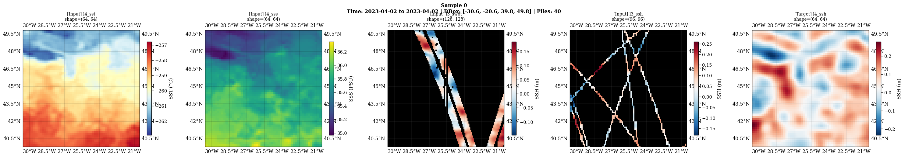
=== Sample metadata ===
  bbox       : (-30.581661323117572, -20.581661323117572, 39.82802218501835, 49.82802218501835)
  time_range : ('2023-04-02', '2023-04-02')
  n_files    : 40

=== Input tensor shapes (actual vs requested) ===
  l4_sst      : data=(64, 64)  requested=(64, 64)  lats=(64,)  lons=(64,)
  l4_sss      : data=(64, 64)  requested=(64, 64)  lats=(64,)  lons=(64,)
  l3_swot     : data=(128, 128)  requested=(128, 128)  lats=(128,)  lons=(128,)
  l3_ssh      : data=(96, 96)  requested=(96, 96)  lats=(96,)  lons=(96,)

=== Target tensor shapes (actual vs requested) ===
  l4_ssh      : data=(64, 64)  requested=(64, 64)

=== Shared coords ===
  lat: (64,)  range [39.83°, 49.83°]
  lon: (64,)  range [-30.58°, -20.58°]
# Figure 3: Visualize all variables in this sample using the built-in method.
# It handles: cartopy projection, per-variable colormaps, dark bg for SSH/SWOT,
# NaN masking for sparse L3 data, and a descriptive suptitle.
dataset.visualize_sample(
    sample,
    title="Sample 0",
    max_cols=5,
    save_path=f"{OUTPUT}_sample0.png" if OUTPUT else None,
)
/usr/local/lib/python3.12/dist-packages/cartopy/io/__init__.py:242: DownloadWarning: Downloading: https://naturalearth.s3.amazonaws.com/10m_physical/ne_10m_land.zip
  warnings.warn(f'Downloading: {url}', DownloadWarning)
/usr/local/lib/python3.12/dist-packages/cartopy/io/__init__.py:242: DownloadWarning: Downloading: https://naturalearth.s3.amazonaws.com/10m_physical/ne_10m_coastline.zip
  warnings.warn(f'Downloading: {url}', DownloadWarning)
10. Section 7 – DataLoader and Batching#
collate_ocean_samples is the custom collate function required by DataLoader. It does
two things:
Handles
Nonevalues. If a variable is missing for some samples in the batch, those samples are silently dropped from that variable’s tensor. This means a variable withk < Bvalid samples produces a tensor of shape(k, H, W)– not(B, H, W). Downstream code should account for this.Zero-pads to max shape. If variables or samples have different spatial sizes, tensors are zero-padded to the largest spatial shape in that variable’s batch slice before stacking.
This padding behavior is especially relevant when using patch_sizes overrides
(as in this notebook), because different variables intentionally have different
requested spatial resolutions (64x64, 96x96, 128x128).
The resulting batch tensors still have per-variable shape (k, H_var, W_var) where
k <= B and (H_var, W_var) can differ by variable.
num_workersguidance: Usenum_workers=0for notebooks (no subprocess overhead). For training,num_workers >= 2is safe and recommended – the pre-built file index means workers never access the TACO catalog.
loader = DataLoader(
    dataset,
    batch_size=4,
    shuffle=True,
    num_workers=0,
    collate_fn=collate_ocean_samples,
)

batch = next(iter(loader))
B = len(batch["metadata"]["bboxes"])

print(f"Requested batch size: {B}\n")
print("Top-level batch keys:", list(batch.keys()))

print("\nInput tensor shapes (k, H, W):")
for var, tensor in batch["inputs"].items():
    req = PATCH_SIZES.get(var, (IMAGE_SIZE, IMAGE_SIZE))
    if tensor is not None:
        k = tensor.shape[0]
        missing = B - k
        note = f"  <- {missing} sample(s) missing" if missing > 0 else ""
        print(f"  {var:<12}: {tuple(tensor.shape)}  requested={req}{note}")
    else:
        print(f"  {var:<12}: None  requested={req}  (no data for any sample)")

print("\nTarget tensor shapes (k, H, W):")
for var, tensor in batch["targets"].items():
    req = PATCH_SIZES.get(var, (IMAGE_SIZE, IMAGE_SIZE))
    shape = tuple(tensor.shape) if tensor is not None else "None"
    print(f"  {var:<12}: {shape}  requested={req}")

print("\nMetadata summary:")
print(f"  n_bboxes: {len(batch['metadata']['bboxes'])}")
print(f"  n_time_ranges: {len(batch['metadata']['time_ranges'])}")

print("\nSample bboxes in this batch:")
for i, (bbox, tr) in enumerate(
    zip(batch["metadata"]["bboxes"], batch["metadata"]["time_ranges"])
):
    print(f"  [{i}] bbox={bbox}  time={tr}")
Requested batch size: 4

Top-level batch keys: ['inputs', 'targets', 'coords', 'metadata']

Input tensor shapes (k, H, W):
  l4_sst      : (4, 64, 64)  requested=(64, 64)
  l4_sss      : (4, 64, 64)  requested=(64, 64)
  l3_swot     : (4, 128, 128)  requested=(128, 128)
  l3_ssh      : (4, 96, 96)  requested=(96, 96)

Target tensor shapes (k, H, W):
  l4_ssh      : (4, 64, 64)  requested=(64, 64)

Metadata summary:
  n_bboxes: 4
  n_time_ranges: 4

Sample bboxes in this batch:
  [0] bbox=(-20.07062142954446, -10.07062142954446, 42.243402739666195, 52.243402739666195)  time=('2023-05-31', '2023-05-31')
  [1] bbox=(-34.921500926893884, -24.921500926893884, 24.9536389472299, 34.953638947229905)  time=('2023-06-10', '2023-06-10')
  [2] bbox=(-33.27111972591208, -23.27111972591208, 15.22574248031496, 25.22574248031496)  time=('2023-06-16', '2023-06-16')
  [3] bbox=(-30.581661323117572, -20.581661323117572, 39.82802218501835, 49.82802218501835)  time=('2023-04-02', '2023-04-02')
11. Section 8 — Query Persistence#
Persisting your query sets is essential for reproducible experiments. The same random seed produces the same queries within a single Python session, but not necessarily across library versions or NumPy updates. Saving queries to disk guarantees that you can reload the exact same training/evaluation split months later.
QueryGenerator.save_queries writes:
<path>.parquet— the query table (bbox + time fields)<path>.json— optional metadata sidecar (any dict you want to attach)
QUERY_SAVE_PATH = Path("./train_queries_north_atlantic")

# Save
QueryGenerator.save_queries(
    train_queries,
    QUERY_SAVE_PATH,
    metadata={
        "region":      "North Atlantic",
        "bbox":        list(STUDY_BBOX),
        "patch_size":  str(PATCH_SIZE),
        "date_range":  list(TRAIN_DATE_RANGE),
        "n_queries":   len(train_queries),
    },
)
print(f"Saved {len(train_queries)} queries to {QUERY_SAVE_PATH}.parquet + .json")

# Reload
reloaded_queries, meta = QueryGenerator.load_queries(QUERY_SAVE_PATH)
print(f"Reloaded {len(reloaded_queries)} queries")
print(f"Metadata: {meta}")

# Verify round-trip
match = all(
    r.to_dict() == o.to_dict()
    for r, o in zip(reloaded_queries, train_queries)
)
print(f"\nAll queries match original: {match}")
Saved 100 queries to train_queries_north_atlantic
Saved 100 queries to train_queries_north_atlantic.parquet + .json
Reloaded 100 queries
Metadata: {'n_queries': 100, 'generated_at': '2026-03-27T00:10:24.569161', 'region': 'North Atlantic', 'bbox': [-80, -10, 10, 55], 'patch_size': '10deg', 'date_range': ['2023-04-01', '2023-06-30']}

All queries match original: True
Summary#
Component |
Purpose |
Key parameter |
|---|---|---|
|
Spatial-temporal sample specification |
|
|
Geographic window size with lat correction |
|
|
Produces training (random) and eval (grid) queries |
|
|
Pre-indexed PyTorch Dataset |
|
|
DataLoader collate fn |
handles |
Further Reading#
For a deeper intuition on how query-generation parameters affect spatial coverage and temporal cadence, see: Spatio-Temporal Query Generation Intuition