Dataset Description#
OceanTACO is a multi-source oceanographic dataset covering five sea surface variables, organized as regional NetCDF tiles and hosted on HuggingFace.
HuggingFace dataset: nilsleh/OceanTACO
Dataset Versions and Coverage#
OceanTACO is released in two temporal versions to support both SWOT-era and longer pre-SWOT analyses.
Core version:
2023-03-29to2025-08-01(includes SWOT calibration and science phases).Extended version:
2015-01-01to2023-03-29(all modalities except SWOT).Shared boundary date: both versions meet at
2023-03-29, which allows seamless concatenation.
Temporal indexing is daily. The core period contains 856 daily indices, and the extended period contains 3009 daily indices.
Processing Levels and Sensor Semantics#
OceanTACO combines products with different observational and modeling characteristics:
L3 observations: preserve native or near-native sampling geometry and sparse coverage.
L4 products: gap-filled mapped fields optimized for spatial completeness.
Reanalysis (GLORYS): physically consistent model-assimilated fields.
In situ (Argo): independent profile observations for validation and cross-checking.
These levels are complementary but not interchangeable. Differences in sampling, mapping, and assimilation should be considered when comparing products.
Data Sources#
OceanTACO aggregates products from five observational categories:
Category |
Sources |
Variables |
|---|---|---|
L4 gridded (fused/interpolated) |
DUACS, CMEMS |
SSH (SLA), SST, SSS, Wind |
L3 along-track (swath) |
DUACS, SMOS, SWOT |
SSH, SSS ascending/descending |
GLORYS reanalysis |
CMEMS GLORYS12 |
SSH, SST, SSS, currents (u/v) |
Argo floats |
Argo GDAC |
Temperature profiles (point source) |
Variables#
The following variables are available in OceanTACO. Use the token string when constructing OceanTACODataset.
Token |
NetCDF variable |
Description |
Units |
|---|---|---|---|
|
|
L4 Sea Level Anomaly |
m |
|
|
L4 Sea Surface Temperature (auto-converted to °C on load) |
°C |
|
|
L4 Sea Surface Salinity |
PSU |
|
|
L4 Eastward Wind |
m/s |
|
|
L3 SST |
K |
|
|
L3 SMOS SSS (ascending pass) |
PSU |
|
|
L3 SMOS SSS (descending pass) |
PSU |
|
|
L3 along-track SSH |
m |
|
|
SWOT SSH anomaly |
m |
|
|
Argo float temperature profiles (point source) |
°C |
|
|
GLORYS reanalysis SSH |
m |
|
|
GLORYS reanalysis SST |
°C |
|
|
GLORYS reanalysis Salinity |
PSU |
|
|
GLORYS reanalysis eastward current |
m/s |
|
|
GLORYS reanalysis northward current |
m/s |
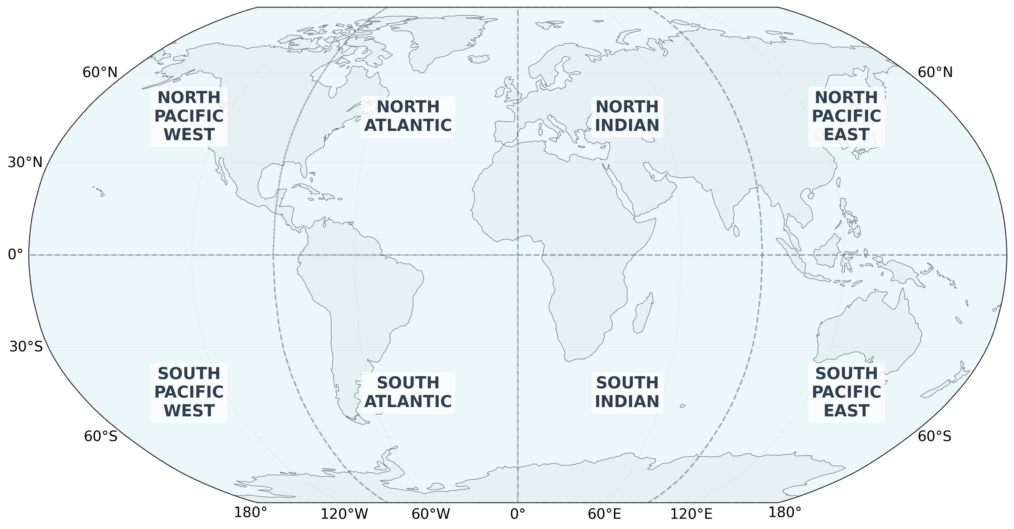
Ocean Regions#
The global ocean is divided into 8 equal 90°×90° tiles. Each region corresponds to one directory in the dataset.
Region |
Longitude |
Latitude |
|---|---|---|
|
−180° to −90° |
−90° to 0° |
|
−90° to 0° |
−90° to 0° |
|
0° to 90° |
−90° to 0° |
|
90° to 180° |
−90° to 0° |
|
−180° to −90° |
0° to 90° |
|
−90° to 0° |
0° to 90° |
|
0° to 90° |
0° to 90° |
|
90° to 180° |
0° to 90° |
Spatial and Temporal Indexing#
OceanTACO uses a fixed global indexing model designed for reproducible cross-source querying:
The ocean is partitioned into 8 fixed regional tiles.
Data are indexed daily.
Each sample is queryable by time window, region, data source, and variable token.
Because the internal sample layout is consistent across products and processing levels, the same data-access workflow can be reused across sensors and studies.
Data Format#
Local directory structure#
When downloaded locally, OceanTACO follows this layout:
DATA/
└── <YYYY_MM_DD>/
    └── <REGION_NAME>/
        ├── l4_ssh.nc
        ├── l4_sst.nc
        ├── l4_sss.nc
        ├── l3_ssh.nc
        ├── l3_swot.nc
        ├── glorys.nc
        └── ...
NetCDF encoding#
Files use HDF5/NetCDF4 with scaled int16 encoding and lossless zlib compression. The tile format is compatible with xarray and h5netcdf. Spatial coordinates follow a regular lat/lon grid; Argo profiles use an unstructured point dimension.
Processing Workflow and Known Limitations#
OceanTACO generation follows three high-level steps:
Regional tiling of daily global products.
Conservative binning/regridding of sparse L3 observations.
Storage encoding with scaled
int16and lossless compression.
Important interpretation caveats:
Projection: data are stored in WGS84 (
EPSG:4326), which is not area-preserving and introduces stronger distortion toward high latitudes.L3 gridding behavior: binning preserves observed sampling patterns; additional gap-filling is not introduced at this stage.
Uncertainty interpretation: aggregated per-cell uncertainty primarily reflects within-track variability and may not fully capture between-track sampling differences.
Cross-level comparison: L4 and reanalysis fields include mapping/assimilation effects and should be interpreted accordingly when compared to L3 or in situ observations.
HuggingFace Access#
OceanTACO is hosted on HuggingFace and can be accessed without downloading the full dataset.
Stream via tacoreader#
from ocean_taco.dataset.retrieve import HF_DEFAULT_URL, load_hf_dataset, load_tile_nc

dataset_hf = load_hf_dataset(HF_DEFAULT_URL) # TACO df

# Load one named-region tile
ds = load_tile_nc(
    dataset_hf,
    date="2024-06-01",
    tile="NORTH_ATLANTIC",
    data_source="l4_sst",
    cache_dir="./cache",   # optional local cache
)
Load all tiles covering a bounding box#
from ocean_taco.dataset.retrieve import load_bbox_nc

ds = load_bbox_nc(
    dataset_hf,
    date="2024-06-01",
    bbox=(-80, -30, 25, 50),  # (lon_min, lon_max, lat_min, lat_max)
    data_source="l4_sst",
)
Download full snapshot (huggingface_hub)#
from huggingface_hub import snapshot_download

local_dir = snapshot_download(repo_id="nilsleh/OceanTACO", repo_type="dataset")
Licenses#
Code: Apache 2.0
Dataset: Creative Commons Attribution 4.0 International (CC BY 4.0)
See the OceanTACO Dataset Card for full license information, required attribution, acknowledgements, and citations.